The research activity is based on the analysis and simulation of extreme weather conditions that contribute to the propagation and fueling of arson fires that occur in the Sicily region. The physical-mathematical algorithm created for the calculation of the Fire Index in Sicily is based on two contributions:
- parameter that takes into account the aridity factor: it gives an indirect estimate of the moisture content of the soil considering the conditions of the previous 40 days;
- meteorological variables such as temperatures, relative humidity, wind intensity and precipitation recorded in the last 48 hours.
In this reference framework, by way of example, we report what happened on May 14, 2020, where arson fires were fueled by intense hot and dry winds.
The synoptic table highlighted the presence of an anticyclonic promontory on the central Mediterranean and a baric depression near the Iberian Peninsula; these conditions gave rise to an intense advection of hot air coming from North Africa. In the southern regions of our peninsula, and in particular in Sicily, temperatures were recorded with values well above the climatic averages expected for the period, with maximum peaks close to 40 °C in the Palermo area, to which are added gale force winds arriving from south-eastern quadrants, with gusts close to 80 km/h (as shown in the figures below).

Figure 1: Map of 2 meter temperatures forecast for May 14, 2020.
In particular, in the Palermo area, maximum values close to 40 °C were expected.

Figure 2: Wind map at 10 meters. Black vectors indicate direction
and the wind direction, colors and intensity expressed in km/h.
The map below reproduces the graphic result of the algorithm created, and in the experimental phase, relating to the day of 14 May 2020. In particular, the risk index recorded values between 70 – 90% on the Tyrrhenian sector of Palermo and Messina, areas where the fires were recorded.
The Fire index can be interpreted with the following classification:
0 – 10% VERY LOW fire risk
10 – 30% LOW fire risk
30 – 40% MODERATE fire risk
40 – 60% HIGH fire risk
60 – 80% VERY HIGH fire risk
>80% EXTREME fire risk
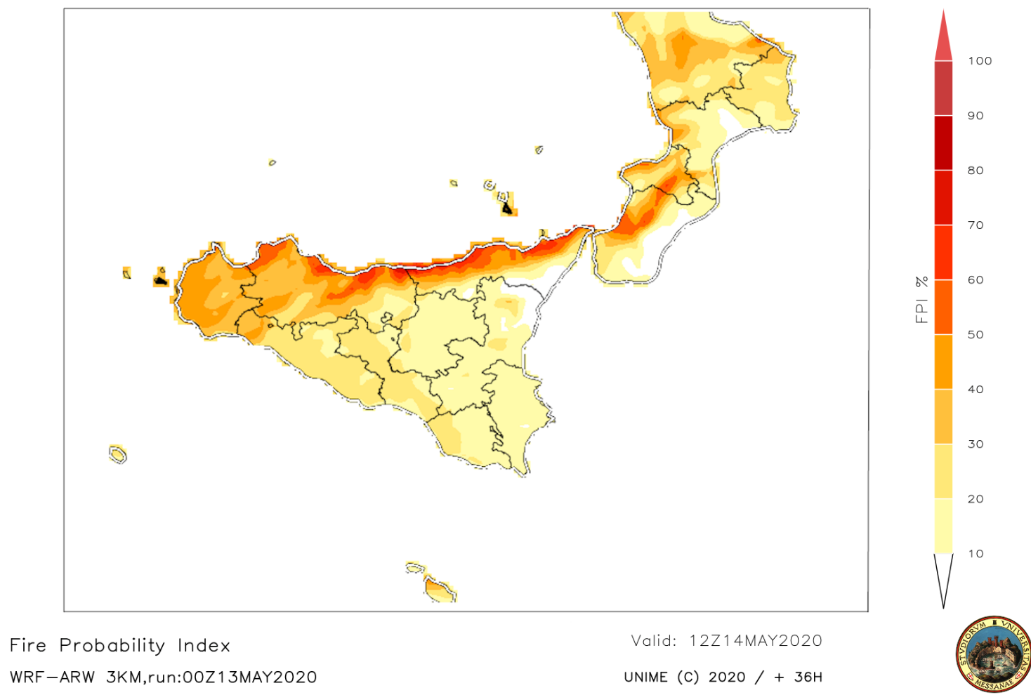
Figure 3: Map with 3 km spatial resolution. Fire Index expressed as a percentage of risk.
As can be seen, the risk index recorded values on 14 May 2020
between 70 and 90% on the Tyrrhenian sector of Palermo and Messina.